Drone Photography and Video
Exploring the Boundless Applications

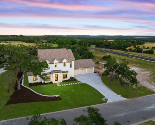
Lakeway, Texas is home to some incredible hillside architecture. Real estate photography by Boko Media, captured Feb 2024.
In recent years, drone technology has revolutionized various industries, offering unparalleled perspectives and opportunities that were once unimaginable. Among the most compelling applications of drones is their use in photography and videography. These unmanned aerial vehicles (UAVs) equipped with high-quality cameras have opened up a world of possibilities for capturing stunning aerial imagery and footage. From breathtaking landscapes to dynamic event coverage, the applications of aerial photography and video are diverse and continually expanding.
Aerial Photography and Videography
Aerial technology has revolutionized the field of photography and videography, offering a plethora of possibilities beyond conventional methods. With their agility and versatility, drones have become indispensable tools for capturing breathtaking imagery from the skies. Gone are the days when aerial shots were reserved for costly helicopter rides or specialized aircraft rentals. Now, photographers and videographers can effortlessly navigate drones to capture stunning vistas, architectural masterpieces, and dynamic cityscapes with precision and creativity.
The aerial perspective offered by drones infuses visual storytelling with a newfound depth, allowing for immersive narratives that transcend traditional boundaries. From majestic panoramas to intimate details, drones empower artists to showcase the world from a fresh and captivating angle, captivating audiences and redefining the art of photography and videography.

Drone photography is always great at twilight or when taking photos of waterfront homes.

Aerial photography is a major part of the presentation of any real estate listing.
Real Estate Marketing
In the realm of real estate, drone photography and video have emerged as indispensable tools for showcasing properties, transforming the way listings are presented to potential buyers. Aerial shots, captured with precision and detail, provide viewers with a comprehensive understanding of a property’s layout, surrounding environment, and unique features.
From suburban homes to urban condominiums and sprawling estates, drones offer the capability to capture stunning footage that highlights the full scope and potential of a property. By offering a bird’s-eye view, drones enable prospective buyers to visualize themselves within the space, fostering a deeper connection and understanding of the property’s appeal. Boko Media is truly the best real estate aerial photography Austin has to offer!
Moreover, in an increasingly competitive market, leveraging aerial technology can significantly enhance a real estate listing’s visibility and desirability. With the ability to showcase properties from captivating angles and perspectives, drone-captured footage stands out amidst traditional listings, attracting more attention from potential buyers. Whether it’s showcasing the expansive grounds of a countryside estate or the proximity of a suburban home to local amenities, drone photography and video elevate the presentation of real estate listings, ultimately helping sellers to differentiate their properties and facilitate faster sales transactions.
Construction and Surveying
Drones have rapidly become indispensable assets within the construction and surveying industries, offering a versatile array of applications ranging from site inspection to progress monitoring and mapping. Their capacity to capture high-resolution imagery coupled with the capability to generate intricate 3D models of both terrain and structures has revolutionized traditional methodologies. Construction companies and surveyors alike are leveraging drones to expedite processes, optimize project planning, and elevate overall operational efficiency to unprecedented levels.
In the realm of site inspection, aerial photography provides unparalleled access to remote or hazardous areas, reducing safety risks for personnel while simultaneously offering comprehensive data collection capabilities. By autonomously navigating through construction sites, drones can meticulously capture visual data, enabling project managers to identify potential issues early on and implement timely solutions. Furthermore, the integration of drones for progress monitoring facilitates real-time tracking of construction activities, allowing stakeholders to monitor project milestones, assess resource allocation, and ensure adherence to schedules with greater precision.
Additionally, drones have redefined the landscape of mapping and surveying by offering swift and accurate data acquisition across vast expanses of land. By employing advanced imaging technologies, drones can generate highly detailed maps and topographic models, empowering surveyors to conduct thorough analyses and make informed decisions regarding land development projects. Whether it’s assessing terrain characteristics, measuring volumetric changes, or conducting property surveys, drones provide unparalleled efficiency and accuracy, thereby enhancing the quality and reliability of surveying operations.
As drones continue to evolve and integrate cutting-edge technologies, their role within the construction and surveying industries will undoubtedly continue to expand, driving innovation and efficiency across various facets of these sectors.
Environmental Monitoring and Conservation
Drones have emerged as indispensable tools in the realm of environmental science and conservation, offering unprecedented capabilities for monitoring ecosystems, wildlife populations, and natural resources. These technological marvels enable researchers to conduct comprehensive aerial surveys of remote or otherwise inaccessible regions, providing invaluable data on ecosystem health and biodiversity. By employing drones, scientists can track changes in vegetation cover over time, monitor the expansion or contraction of habitats, and assess the impacts of human activities on delicate ecosystems, facilitating informed decision-making for conservation efforts.
Moreover, the integration of thermal imaging cameras on drones has revolutionized wildlife monitoring and anti-poaching initiatives. Equipped with this advanced technology, they can detect heat signatures from animals even in dense vegetation or during nighttime hours, allowing researchers to conduct more accurate population surveys and track the movements of endangered species. Furthermore, drones serve as powerful deterrents against illegal poaching activities by providing real-time surveillance capabilities over protected areas. Conservationists can swiftly respond to potential threats identified by drone patrols, thereby safeguarding vulnerable wildlife populations and preserving biodiversity hotspots.
In essence, drones represent a game-changing tool in the arsenal of environmental scientists and conservationists, offering unparalleled capabilities for monitoring and protecting Earth’s natural treasures. As technology continues to advance, drones will undoubtedly play an increasingly pivotal role in shaping conservation strategies and safeguarding the planet’s ecological heritage for future generations.
Event Coverage and Marketing
Drones have emerged as a popular tool for capturing dynamic aerial footage of various Austin event photography appointments, including concerts, sports competitions, and festivals. Their agility and versatility allow them to navigate the skies effortlessly, capturing sweeping aerial shots of large gatherings from unique vantage points. Boko Media harnesses this innovative technology to provide captivating video content that enhances event coverage and marketing campaigns. Whether it’s showcasing the elegance of a corporate event or the vibrancy of a music festival, drone footage adds an exciting dimension to any occasion, engaging audiences and leaving a lasting impression on viewers.
In addition to event coverage, Boko Media leverages drones to create compelling marketing content for businesses. From showcasing scenic landscapes to highlighting product features, drones offer a fresh perspective that captivates audiences and sets brands apart. By incorporating aerial footage into marketing strategies, businesses can effectively communicate their message, attract customers, and differentiate themselves in competitive markets. Whether it’s for promotional videos, commercials, or social media content, drones provide a powerful tool for businesses to elevate their marketing efforts and connect with their target audience in impactful ways.

Search and Rescue Operations
During natural disasters or missing persons cases, the integration of drones equipped with advanced thermal imaging cameras and GPS technology proves to be invaluable for search and rescue operations. These unmanned aerial vehicles possess the capability to swiftly and effectively cover vast areas, enabling search teams to efficiently survey the affected regions.
By leveraging their real-time aerial footage capabilities, this technology empowers search teams with critical information to identify survivors or pinpoint individuals in distress rapidly. Their agility and capacity to access hard-to-reach or hazardous locations, which might otherwise be inaccessible to conventional search teams, render drones indispensable assets in emergency response efforts.
Moreover, the utilization of drones in emergency situations significantly enhances the safety and effectiveness of search and rescue operations. By minimizing the need for human personnel to traverse treacherous terrain or hazardous environments, drones mitigate risks and expedite the search process. Additionally, their ability to provide high-resolution imagery, even in low-light conditions or adverse weather, ensures continuous surveillance and monitoring of the affected areas.
This enables rescue teams to adapt their strategies in real-time, optimizing resources and maximizing the chances of locating and aiding survivors. In essence, drones equipped with thermal imaging and GPS technology represent a crucial advancement in emergency response capabilities, offering a swift and reliable solution for identifying and assisting individuals in urgent need of rescue and assistance.
Boko Media: Your Premier Choice for Drone Photography and Video in Austin
Boko Media exemplifies excellence in harnessing drone technology for real estate photography and videography, setting itself apart as a premier choice not only in Austin but also beyond. With a team of skilled aerial pilots and state-of-the-art equipment, Boko Media consistently delivers captivating aerial imagery and video footage that mesmerizes audiences and enhances visual storytelling experiences.
Whether it’s showcasing properties for real estate agents, conducting aerial site surveys for construction companies, or providing dynamic event coverage for event planners, Boko Media offers tailored solutions to meet diverse needs. Their extensive expertise and resources ensure that clients’ visions are brought to life with precision and creativity.
Committed to professionalism, innovation, and exceeding customer expectations, Boko Media sets a benchmark for excellence in drone photography and videography services.
In conclusion, the applications of drone videography and photography span across a multitude of industries and fields, offering endless possibilities for creative expression and practical utility. From capturing awe-inspiring aerial landscapes to assisting in critical search and rescue missions, aerial photography continues to revolutionize how we perceive and engage with our surroundings.
As technological advancements propel the capabilities of aerial technology forward, Boko Media remains at the forefront, offering unparalleled services in Austin and neighboring areas. For those seeking unrivaled visual storytelling and aerial imaging solutions, Boko Media emerges as the trusted partner of choice, where the sky truly becomes the canvas for limitless possibilities.


